


 The stable isotopes of hydrogen and oxygen have a long history of use in hydrology and paleoclimatology. Two stable isotopes of hydrogen (1H and 2H) and three of oxygen (16O, 17O and 18O) occur naturally in waters and in biological and geological materials. Of these, 1H, 2H, 16O and 18O are abundant and can be easily measured by mass spectrometry.
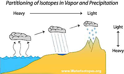
A simple rule governs the partitioning of water isotopes in most hydrological processes: heavy isotopes occur preferentially in liquid (or solid) phases and the light isotopes in the gaseous phase. This partitioning among the phases is at the root of most applications involving water isotopes, because it leads to progressive evolution of the water isotope composition of climatological air masses as they move across the surface of the earth gaining and losing moisture. The most fundamental example of this process involves the progressive drying of an air mass that has become saturated with water over the oceans and then travels over land. Because the air mass loses the heavy isotopes (2H and 18O) faster than the light isotopes, the heavy isotope is distilled from the air mass. Thus, the ratio of the heavy to light isotopes in precipitation falling from the air mass decreases with time as more and more water is lost as precipitation.
The temporal partitioning of isotopes described above also leads to strong, predictable, spatial partitioning of the isotopes across landscapes. At the root of these patterns is a combination of the distillation process described above and meteorology. We have seen how water isotope ratios change as air masses move across the surface of the earth, and to understand how this produces spatial patterns we need only consider that climatic processes direct the movement of air masses in more or less predictable ways. The water isotope ratios of precipitation typically decline along these circulation 'pathways', producing geospatial gradients in the isotope ratio of water delivered to the Earth surface. The slope of these spatial water isotope gradients ultimately depends on the rate at which water is lost as air masses travel along pathways, which is related to a large number of climatological factors but in the end boils down to how quickly air is cooled and/or lifted along the pathway.
This concept applies to individual air masses, but can also be considered at the level of average climatic patterns that characterize seasonal or annual average moisture transport over different regions of the globe. For instance, the state of Minnesota receives moisture from a variety of sources throughout the year, including a relatively small contribution from wintertime storms sourced in the North Pacific and Hudson Bay and a larger contribution from summertime storms that deliver moisture from the Gulf of Mexico. We would expect, then, that the average isotope ratio of water falling in Minnesota would reflect this balance of moisture sources and the associated distillation characteristic of those circulation pathways. On a very general level, these patterns are stable over the course of years or decades, but on a more subtle level they are subject to variability from year to year (for instance, annual changes in the average wintertime trajectory of the jet stream over the US and Canada or the intensity of wintertime storms in California related to ENSO cycles). Thus, the long-term average geospatial distribution of precipitation water isotope ratios should reflect the average climatology of a region, and shorter-term averages may carry information about climatic patterns on shorter time scales.
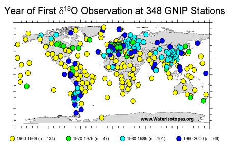 Realizing the potential for application of stable water isotope ratios in a number of scientific disciplines, the World Meteorological Organization and International Atomic Energy Agency established the Global Network for Isotopes in Precipitation (GNIP) in the early 1960s. This worldwide network of precipitation-monitoring stations persists and continues to evolve today. It has gathered stable water isotope data at a monthly time resolution at almost 400 stations, providing an incredible resource for the study of precipitation water isotope ratios in temporal, climatic, and geospatial contexts. The large database of isotope ratio measurements compiled as a part of this program provides the foundation for the work presented on this website, and we are indebted to those who have coordinated and contributed to the GNIP effort. Working with the GNIP data in a geospatial context presents a unique set of problems, however. Primary among these, the GNIP measurements are distributed very unevenly in time and in space. For instance, the data set includes very good geographic coverage over China, but almost none of the Chinese stations were operative before the 1980s. This contrasts with areas such as the United States and Africa, where data collection began much earlier, but many monitoring stations had ceased operation by the time the Chinese stations came online. This spatial and temporal unevenness is of concern when comparing data from different regions, and in various places on this site we describe attempts that we have made to minimize the impact of sampling artifacts on our analyses.